What is the Austin "tent"? Setback planes explained
Why it is called a tent
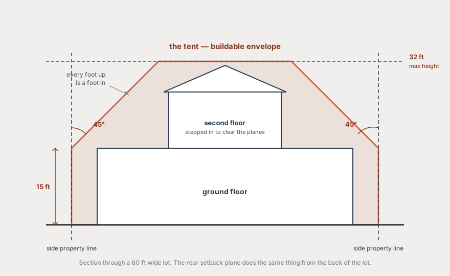
Setbacks draw a footprint on the ground. The setback planes do something different: they draw a shape in the air, and your house has to fit inside it.
From each side property line, imagine a vertical wall rising 15 feet. At the top of that wall the surface tilts inward at 45 degrees and keeps going up. The same thing happens from the rear property line. Where those sloping surfaces meet overhead, you get a form that looks like a tent pitched over the lot.
Because the slope is 45 degrees, the arithmetic is easy: every foot you move in from the property line buys you a foot of height. At 15 feet above the ground you can build right at the setback line; at 25 feet above the ground you must be 10 feet further in.
Except as provided in subsection D, an inwardly sloping 45-degree angle side setback plane begins at a horizontal line 15 feet directly above the side property line. The 15-foot height of the horizontal line is established for 40-foot deep portions of the lot beginning at the building line and extending to the rear of the lot, except that the last portion at the rear of the lot may be less than 40 feet deep.
The 40-foot portions, and why they matter on a slope
On a flat lot you can ignore this. On a sloping one you cannot.
The plane does not follow the ground continuously. The lot is divided into 40-foot deep portions running from the building line to the rear, and each portion gets its own horizontal reference line. Within a portion the height is measured at the highest of the four corner elevations defining it.
Taking the highest corner is generous to the builder on a downhill lot — the whole portion is referenced to the high point rather than to the ground beneath each part of the wall. It also means the plane steps down in 40-foot increments rather than sloping smoothly, so a wall that clears the plane in one portion can breach it in the next.
The last portion at the rear may be shorter than 40 feet, and the rear plane keys off that last portion's elevation.
The tent is only one of four constraints
§2.6.C defines the buildable area as the smallest area within all of:
- the front, side and rear yard setbacks;
- the maximum height limit under §2.2 — 32 feet outside the 100-year floodplain, 35 feet inside it;
- the side setback plane; and
- the rear setback plane.
"Smallest" is the operative word. These are not alternatives and you do not get to pick the most favorable. Every one applies at once, and the envelope is whatever survives all of them.
On a wide lot the height limit usually binds before the planes do. On a narrow infill lot — which is most of Central Austin — the planes bind first, and they are what force the upper story to step in.
What may poke through
§2.6.E is a closed list. A structure may not extend beyond a setback plane except for:
- A roof overhang or eave, up to two feet beyond the plane.
- A chimney, vent, antenna, or energy conservation or production equipment not designed for occupancy.
- Either of two roof-form allowances — not both:
- the 30-foot side-gabled roof exception: a side-gabled roof structure on each side of the building, total horizontal length no more than 30 feet measured along the intersection with the side setback plane; or
- the gables plus dormers exception: gables or a shed roof up to 18 feet total on each side, and dormers up to 15 feet total on each side.
The two-foot eave allowance is worth designing around. It is measured beyond the plane, so it effectively buys two feet of roof at the edge without moving the wall.
Adding a second story to an older one-story house
§2.6.D exists because the tent would otherwise make many second-story additions impossible on houses built before the ordinance.
If you are adding a second story to a one-story building that was constructed, or permitted for original construction, before 1 October 2006, you may choose an alternative plane for the portion of the project within that original footprint: an inwardly sloping 45-degree plane beginning directly above the outermost side wall at the height of the original first floor wall plate plus ten and one-half feet.
The code defines the wall plate precisely as the lowest point of the existing first floor ceiling framing that intersects the exterior wall.
Two limits on this. Any portion of the construction outside the original footprint uses the ordinary plane. And if any part of the work requires removing or demolishing exterior walls, the ordinary plane applies to the entire project — so a deep remodel can lose the exception altogether.
How height is actually measured
The limit is 32 feet outside the 100-year floodplain and 35 feet inside it. That distinction was added in 2019 — a lot of published advice still states a flat 32 feet.
It is measured vertically from the average of the highest and lowest grades adjacent to the building — not from the front door, and not from the lowest point.
What you measure to depends on the roof:
- Flat roof — the highest point of the coping.
- Mansard roof — the deck line.
- Pitched or hip roof — the gabled roof or dormer with the highest average height. (The 2008 amendment changed this from "the average height of the highest gable", which is a subtly different test.)
- Anything else — the highest point of the building.
Grade is the lower of natural or finished grade, with narrow exceptions for sites raised out of the 100-year floodplain and for Mueller.
Who does not have a tent
The tent is a Subchapter F device, so anything outside Subchapter F does not have one:
- Duplex, two-unit and three-unit projects. HOME Phase 1 removed those uses from the Subchapter F applicability list. No tent, no sidewall articulation.
- Small lots under 5,750 sq ft. §25-2-779(I) disapplies Subchapter F for property zoned SF-3 or more restrictive, except for the floor area provision.
- Anything outside the boundary formed by Highway 183, Ben White Boulevard, Loop 360, Loop 1 and the Colorado River.
Base zoning height limits still apply in all of those cases — you are escaping the planes, not the height limit.
How the tent shapes a house
The tent is the single biggest reason Central Austin infill houses look the way they do. A narrow lot with planes rising from both sides forces the upper story inward, which is why so many recent houses have a full-width ground floor and a visibly narrower second floor, often with the roof pitching away at the edges.
Designing against it rather than with it is expensive. We set the massing inside the tent early, because a plan that needs the roof re-cut late is a plan that has already cost somebody money.
The gable and dormer allowances are where the character comes from. Eighteen feet of gable and fifteen feet of dormer per side is enough to give a roof real articulation — but it is a budget, and spending it on one dramatic gable means the rest of the elevation stays flat.
Common questions
Send us an address and we will tell you what we find
We do this research ourselves on every project we take on — zoning, floodplain, watershed, trees, whether it is a legal lot. Send us an address and we will run it and tell you what we find. It works the same whether you own a vacant lot, a house you are thinking of adding a unit to, or a house you are thinking of replacing. No charge and no strings, and if it is a bad lot we will say so.
Send us an addressWe are homebuilders, not the City of Austin. This page explains how we read the code in practice — it is not legal advice and it is not an official determination. Always confirm with Austin Development Services before you rely on it for a project. The authoritative text is the Austin Land Development Code; permitting questions go to Austin Development Services Department.